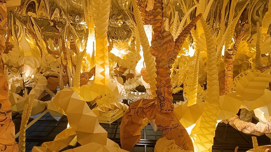
Infinity Room
Credit: Special arrangement
'Maps Unfolded’, an exhibition of sculptures and installations by Delhi-based artist Ankon Mitra, ended recently at Kalakriti Gallery in Hyderabad. It was a fascinating combination of art, design, and architecture. The entire exhibition was built around archival maps from the curator Prshant Lahoti’s collection—the Kalakriti Archives, which is one of the largest private repositories of historic maps in India.
Mitra, a trained architect, is known for his large-scale installations that are primarily based on various hand-folding techniques such as origami. In this show, he used archival maps and prints to locate and represent them amidst historical, geographical and spatial frameworks. Working with the notion of spatial information contained within the abstract symbology of two-dimensional maps and converting them into three-dimensional conceptual expressions, Mitra has combined several disciplines such as science, architecture, design and cartography innovatively.
The artworks, ranging from floral blooms to lenticular pieces, were both abstract and functional. The practice of map-folding to make them easy to carry, and the vast geographical and topographic information transcribed from spherical to planar as contained on the surface of the maps form the basis of the works, while also referencing the Japanese mathematician Koryo Miura’s characteristic folding pattern.
The concept note informs that the maps featured in this exhibition include traditional Indian pilgrimage maps, printed bazaar maps, and city maps, each offering a window into society of the past and present. “Through this exhibition, we have tried to juxtapose the precision behind the science of origami and cartography,” says the curator.
With around 100 artworks, there were several points of interest in the exhibition. The ‘Infinity Room’, an immersive piece with mirrors on all sides, and aerial roots and branches made from archival maps of the Charminar and Red Fort suspended from the ceiling, was reminiscent of a banyan tree. It also alluded to the rail and road networks that span the country and have bourgeoned with time. As a selfie room, it placed the viewer in a contemporary context, while emphasising the interconnectedness of land, the people and civilisations. Another interactive and kinetic piece featured a pinwheel, which invited the viewer to spin it to replicate the earth’s spinning motion along its poles.
‘The Map Flowers’ are cross-cultural offerings — these have been made from old European maps of China and Japan, and drawn by cartographers travelling to the Orient. These were combined with a paper-cutting technique of Slavic origin and with Origami and Kirigami fold techniques from Japan. The large urns were created from religious maps and pilgrimage maps and formed sacred receptacles of spiritual quests. ‘The Votive Urns in Offering’ is inspired by the motifs and iconographic elements from the Utkala style of temple architecture of Jagannath Puri.
The two installations close to the entrance of the gallery, ‘Moons and Constellations’ and ‘Cloud Maps’, reference the blue night sky with the planets, their satellites and the constellations, while the latter forms a gold and black cloud formation based on images released by the European Space Agency (ESA), NASA, ISRO, and other space agencies — representing a stunning and ephemeral moment in time. The heritage buildings of Hyderabad such as the Falaknuma Palace, the Chowmohalla Palace, the Golkonda Fort, Makkah Masjid, Toli Masjid and others are represented as architecture dioramas and models and were installed as pop-ups on the walls.
The duality of images across a 100-year time frame is represented through lenticular maps where the UNESCO World Heritage tagged Map of the Walled City of Jaipur (2019) and An Archival Map of the Navagraha Map of Jaipur City (1885) are juxtaposed, transforming from one to other, based on the viewing angle.
The exhibition succeeded in creating interest in an archival map collection and making the archives accessible to a wider audience. Mitra’s architectural background combined with his deep interest in origami, Ori-tecture as he defines it, forms the aesthetic and visual anchor for each artwork and the overall exhibition. However, it is the layering of narrative and content in each of the artworks to create synergy, context and meaning that amplifies the reading of the works, making it nuanced.
Dab Hand is your art world lowdown. The author is a Bengaluru-based art consultant, curator and writer. She blogs at Art Scene India.