On a 16-day backpacking trip across Sri Lanka, I reached a nondescript coastal town, Mannar, in the northern part of the country. It wasn’t the best-connected place. I had changed two buses to get here from Anuradhapura via Medawachiya in Central Sri Lanka.
Mannar was a windswept town. It had an arid, wild west landscape with isolated patches of sandy shoreline dotted with palmyra trees and empty fishing boats. The entire town carried the smell of fish. It wasn’t the kind of place to offer picture-postcard shots, like the rest of Sri Lanka was known for. But I had my reasons to be here.
I was just 30 kilometres away from India, making it the closest I would be to home from Sri Lankan soil. This small coastal quarter on the northwest edge of Sri Lanka is separated from Dhanushkodi in Tamil Nadu by the Palk Strait. Studies suggest that there was a bridge here, popularly called Adam’s Bridge — a chain of sandbanks that, until the 15th century, connected the two countries. However, storms deepened the channel over centuries and made the bridge inaccessible. And it doesn’t end here. According to legends, this bridge is mentioned in the Hindu epic Ramayana as the place Lord Rama pointed to with the tip of his bow, and Lord Hanuman built a bridge (Setu) to cross the sea to reach Lanka and rescue Sita from Ravan, hence lending the name Ram Setu.
Torn by its past
As I walked around Mannar, it felt like I had travelled to the eighties! There were no fancy restaurants and shops, no supermarkets, no traffic lights, and not even traffic! My red rucksack invited a few curious stares from locals who wondered what I was doing in their non-eventful town. Mannar was reeling from a tense past where the rebel group LTTE had set up base here during the 26-year-long Sri Lankan Civil War. Although the war ended over a decade back, tourism was yet to pick up in this region. A handful of visitors from surrounding districts drop by to see the greater flamingos during the migratory season between December and April. Among newer tourism initiatives to lure the intrepid traveller is the promotion of kite surfing due to its windy location.
But things were not always like this! Mannar had seen better times. It once served as the administrative centre for the Jaffna Kingdom in North Sri Lanka before the Portuguese occupied the region, followed by British colonisation. As the closest border to India, Mannar thrived as an important port city for moving goods and people between India and Ceylon (now Sri Lanka). The town was also known for its lucrative pearl fishing industry until its resources were depleted, killing its pearling industry, however, fishing remains an important source of income for the locals.
An abode in a deserted land
Upon reaching my homestay, after a 15-minute walk from the bus stand, I was welcomed by Jude, my twenty-something host. For a large part, we conversed in broken English about our backgrounds. He then suggested some places I could visit — there was a large irrigation tank with an artificial lake, a cluster of giant baobab trees, and a 400-year-old Catholic shrine that acted as a refugee camp during the Civil War. He graciously offered me his bicycle to ride, and I humbly obliged.
As I pedalled around the quiet neighbourhood, it was deserted, except for the sight of a few wild ponies. I wasn’t sure if this was siesta time or the way of life here. Wary of not venturing too far away, I stopped to grab a lunch of fish curry rice at a nearby no-frills restaurant before returning to my homestay.
Later that evening, I took the bus to Talaimannar — home of the fabled Ram Setu bridge — and the reason I was here. The public bus had stuffed passengers like chickens and the roads got progressively worse on the forty-five-minute journey. After getting off at the last stop, I hailed a rickshaw to the quayside.
Close, yet so far
The view at Talaimannar was a sight to behold. There was a wooden pier, inaccessible and beyond disrepair. I stood facing the pier surrounded by the Indian Ocean on three sides. Somewhere on the hazy horizon was India, near but not in clear sight!
At one point, the Talaimannar pier served as a ferry service between Dhanushkodi and Mannar for more than fifty years until a cyclone hit the Andaman Sea in 1964, destroying the coasts in both countries. The service briefly started from Talaimmanar to Rameshwaram island in Tamil Nadu, but due to political tensions triggered by LTTE, it was terminated and never resumed.
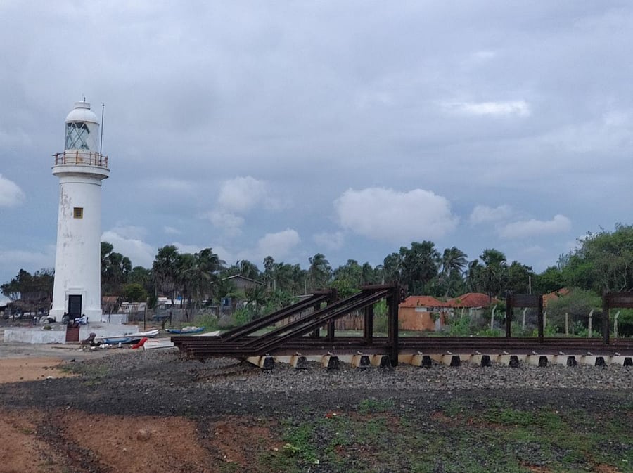
What remains today of Talaimannar is an abandoned lighthouse — its whitewashed tower once guided passing boatmen and ferries stopping here. Adjacent is the dead-end of the railway track and the Talaimannar station that operates a train service to Medawachiya connecting to the rest of Sri Lanka. There is a strong presence of the Sri Lankan navy across the area, not surprisingly because of the close border proximity it shares with India.
I spent a good 45 minutes here under the watchful eye of the navy, observing the sea and sights around me. Angry waves crashed into the pier, and I couldn’t help but think about the magnitude of destruction the cyclone might have caused on that fateful night on both sides of the region. It was a moment to reflect on the power of nature to uproot life and wipe off cities.
My evening excursion had ended on that sombre note as I bid goodbye to Talaimannar, and it dawned on me that Mannar was not so much about the beauty of its landscape, but the resilience of its people.
This humbling visit to an overlooked town brought a refreshing sense of reality to my backpacking adventure in Sri Lanka.