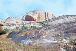

Gudibande is yet another dry and dusty town typical of Kolar district. This little town, about 95 kms north of Bangalore, off the NH 7 seemingly does not generate any interest to the visitor. But for the discerning, it has quite a few things of interest. An old fort on a conical hill, a huge lake that looks like the map of India, temples carved out of boulders et al. As the rough road deviating from the highway leads to the town, the hill fort that blends hazily with the sky when it is grey looms large in the distance.
Closer, a hillock with a few gigantic boulders comes into view. A cave temple hewn out of one such boulder is what Gudibande is named after, meaning a temple on a boulder. However, the more interesting attraction here is the hill fort further down. The big granite hill with its steep and slippery slopes must have been chosen as the ideal setting for the fort at Gudibande. The seven gates at different levels make it another example of Yelu Sutthina Kote. The initial entrances are now gone, and the first gate that has been reinforced with a grilled door is actually the fourth. This entrance leads to a small field with a dilapidated mantap. The next entrance is strong and in good shape with simple star-like designs and openings for guns adorning its walls. A cave formed between two massive boulders must have made a nice vantage point for sentries to keep watch.
Escape routes
There are many natural ponds with an escape route amidst the boulders, for soldiers to flee in case of an emergency. The well-defined sentry rooms at the next gate give a fair idea of the security that was provided to the fortress in those days. The penultimate entrance opens into a fairly large plateau with rock solid bastions at the corners. The area is the domain of the monkeys that feed on the leaves and fruits of the green shrubs growing profusely. Finally the trail climbs between two colossal rocks to the top. The large rectangular mantapa here is believed to have been used to house prisoners. The Shiva shrine at the top, believed to be one of the 108 Jyotirlingas, has been neatly renovated. The strong pillar with a square base has well sculpted images. Viewed from the top, one can guage how steep the surrounding rocky slopes with fortwalls built into them are. It is also from here that the tank of Byrasagara looks like the map of India !
The fort dating back to about 400 years was built by a small time chieftain Byregowda in the middle of the 17th century. He was a sort of Robinhood of those times, known to loot the rich and help the poor. Incidentally, he earned the sobriquet of Havali (menace) Byre Gowda! Though he ruled for no more than three years from 1645 to 1648 AD, the fort remained his legacy.
Rainwater harvesting
Gudibande fort, however, has an interesting feature. With nearly 19 rock ponds all over the fort at different levels, a perfect system of channelising water was made possible which only goes to say that the concept of rainwater harvesting was in practice 400 years ago. The system went into oblivion along with the fort. Today, the town has had to face drinking water problems. Because the borewells were dug deep and the fluoride rich water was consumed, people suffered from bone deformities.
Thanks to the efforts of the local NGO, Vivekanada Yuvaka Sangha, a project was proposed not only to augment the supply of rain water for potable use, but also to revive the ancient system of water harvesting. The project involves shaping up these ponds, some of which are as deep as 10ft, linking with channels, passing through a filtration plant and storage in a large sump. With an average rainfall of 880 mm in the area the overflowing water itself would be enough to meet the needs of the entire town. According to Nagendra of the VYS, a grant of Rs 1.5 crore has since been approved and when completed the drinking water requirements of the area would be fulfilled. That apart the heritage value of this ancient practice would get a boost.
Getting there: Gudibande can be reached by driving on NH 7 for 85 kms and taking a deviation to the left and driving further for 10 kms. It is also well connected by buses.