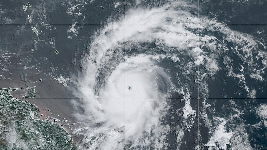
Hurricane Beryl
Credit: NOAA/Handout via Reuters
Beryl developed into a record-breaking Category 4 hurricane Sunday -- the earliest in a season that a storm has reached such strength -- as forecasters warned it would continue to rapidly intensify while moving west toward the Caribbean Sea.
Before Beryl, the earliest Category 4 hurricane was Hurricane Dennis on July 8, 2005.
The first hurricane of the 2024 season, Beryl is expected to bring "life-threatening winds and storm surge" to the Windward Islands, southeast of Puerto Rico and north of Venezuela, the National Hurricane Center said Sunday.
By Sunday afternoon, sustained winds were reaching 130 mph, forecasters said, making it an "extremely dangerous" Category 4 hurricane.
A hurricane warning was issued for Barbados, St. Lucia, St. Vincent and the Grenadines, Grenada and the island of Tobago. The island of Martinique was under a tropical storm warning, while Dominica, Trinidad, and parts of the Dominican Republic and Haiti were under a tropical storm watch.
Life-threatening winds and storm surge were expected in the Windward Islands starting early Monday, the National Hurricane Center said Sunday morning.
Hurricanes in the Atlantic Ocean are now twice as likely to grow from a weak storm into a major Category 3 or higher hurricane within just 24 hours, according to a study published last year.
Devastating winds from Beryl will occur where the eye wall -- the area that surrounds the eye of a hurricane -- scrapes across the islands. Across the higher elevations of the hills and mountains of the islands, the winds might be even stronger.
Beryl is the third-earliest major hurricane to form in the Atlantic, according to Philip Klotzbach, an expert in seasonal hurricane forecasts at Colorado State University. The only hurricanes to have formed earlier in a calendar year were Alma on June 8, 1966, and Audrey on June 27, 1957.
Both made landfall on the U. coastline in the Gulf of Mexico: Alma near St. Marks, Florida, and Audrey near Port Arthur, Texas.
Beryl became a tropical storm late Friday when its sustained winds reached 39 mph. At 74 mph, a storm becomes a hurricane.
Here are key things to know about the storm
-- Swells created by Beryl are expected to reach the Windward and southern Leeward Islands by late Sunday, forecasters said, and are likely to cause life-threatening surf and rip current conditions.
-- The storm is expected to cross the islands of the eastern Caribbean as early as Sunday night before traversing the central Caribbean Sea through the middle of the week.
-- Three to 6 inches of rain, hurricane-force winds and dangerous storm surge are possible in the eastern Caribbean Islands, including Barbados, and St. Vincent and the Grenadines Sunday into Monday.
Countries prepare for Beryl
Dickson Mitchell, prime minister of Grenada, said the country would be under a state of emergency starting at 7 p.m. Sunday.
Except for police and essential workers, "everyone is expected to be in their homes or in a shelter," he said.
In a national address Sunday, Ralph Gonsalves, prime minister of St. Vincent and the Grenadines, urged residents to take the storm seriously, saying that many buildings could lose their roofs.
"There are some persons who are hoping for the best, and we must all do that. But we all have to prepare for the worst," he said.
The prime minister ordered that, beginning at 7 p.m. Sunday, people remain where they are. Emergency shelters were set to open at 6 p.m. Sunday.
In St Lucia, Prime Minister Philip J Pierre announced a countrywide shutdown at 8:30 pm Sunday, with schools and businesses remaining closed Monday.
In Barbados, flights to London and Miami were the last international departures from Grantley Adams International Airport before it closed at 7 pm Sunday. Tourism officials said some residents and a handful of tourists had sought refuge at government-specified shelters.
This hurricane season is expected to be busy.
Forecasters have warned that the 2024 Atlantic hurricane season could be much more active than usual.
In late May, the National Oceanic and Atmospheric Administration predicted 17 to 25 named storms this year, an "above-normal" number and a prediction in line with more than a dozen forecasts earlier in the year from experts at universities, private companies and government agencies.
Hurricane seasons produce 14 named storms, on average.
The seasonal hurricane outlooks were notably aggressive because forecasters looking at the start of the season saw a combination of circumstances that didn't exist in records dating to the mid-1800s: record warm water temperatures in the Atlantic Ocean and the potential formation of the weather pattern known as La Nina.
When it is strong, La Nina typically provides a calm environment in the Atlantic. This allows storms to develop more easily and to strengthen without interference from wind patterns that might otherwise keep them from organizing.